


The Pipeline West-Clipper Gold Project (“PWC”) is subject to an earn-in, and is operated, by Kinross Gold. PWC is located in Lander County, approximately 80 km southwest of Elko. PWC lies within and is directly on strike with the Cortez portion of the prolific Battle Mountain – Eureka Trend of world-class gold and base metal mines. PWC encompasses 24.7 square kms (9.5 square miles) of unpatented mining claims and patented (fee) lands adjacent to properties controlled by the Nevada Gold Mines JV.
Kinross Earn-in Agreement Highlights:

Figure 1: Location of PWC
PWC is within 1 km of the Gold Acres Mine and is positioned between the Cortez Complex of mines operated by the Nevada Gold Mines JV (Barrick/Newmont) and the Swift Project JV between Ridgeline Minerals and Nevada Gold Mines. PWC is centered along the Cortez Structural Zone that appears to control many of the gold deposits within the Cortez portion of the trend (Leonardson, 2010).
PWC has the potential to host significant gold deposits of two genetic types. These target models, along with hybrid situations with genetic commonalities of the two systems, have evolved from Riley Golds’s detailed review of historical drilling, geophysics, and geochemistry, combined with new programs including surface mapping and a new, large soil geochemical sampling program.
The targets at PWC include both structurally-controlled, Carlin-type gold deposits, sometimes referred to as Sedimentary Rock Hosted Gold Deposits (SRHGD) and Reduced Intrusive Related Gold deposits (RIRG). Both target types are in evidence at PWC based upon recent interpretations of the multi-layered data.
Multiple layers of data have combined to yield significant targets for further exploration, including drilling.
Surface Soil Geochem Sampling Program:
Historical surface soil and lithic chip sampling programs presented an intriguing question. Open-ended gold-in-soil anomalies from past programs suggested a northwest trending anomalous zone. This zone coincided with historical and geophysical interpretations and new geological and structural mapping. Based on the multi-layered data, we designed a detailed infill soil program.
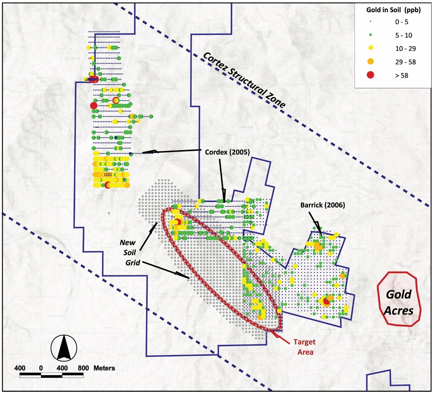
Figure 2: Historic sample grids showing gold-in-soil plus Riley Golds’s new sample grid
A large (1,046 sample) close-spaced soil grid survey was performed in October, 2022. North American Exploration, Salt Lake City, UT conducted the sampling. Sample spacing was 60.9 m (200 feet). The samples were logged, as were the soil profiles and lithic fragments in each sample. The purpose of the soil program was to infill areas not previously sampled by former operators and to verify/level the results from prior soil and lithic chip sampling surveys.
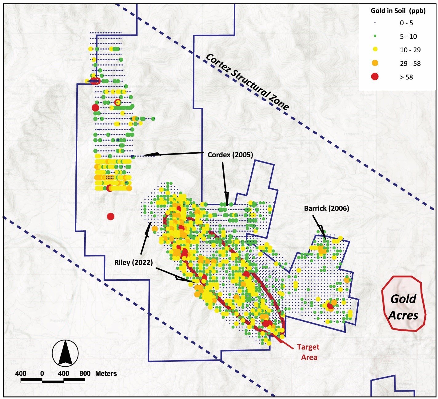
Figure 3: Combined Gold-in-soil results (new gold-in-soil at same ranking as older surveys)
The results of the survey revealed that gold is strongly anomalous compared to older surveys. Arsenic silver, and other pathfinder metal anomalies are also anomalous. The new sampling confirmed older sampling results revealed new, even stronger values in areas not previously sampled. Figure 3 shows the new gold-in-soil results overlain on older survey results. The original target area is outlined in red.
Geophysics:
Historical geophysical work at PWC includes Ground and Aero-Magnetic surveys, Gravity, and CSAMT. Modeling and interpretations were provided by Chet Lide, VP & Managing Geophysicist for by Zonge International, Reno, Nevada. Modeling of the various geophysical surveys in 2022 revealed significant structure-related and alteration anomalies. These interpretations were brought sharply into focus when combined with recent geologic mapping conducted by Mike W. Ressel, PhD, during October 2022. Initial structural interpretations, prior to field mapping, suggested northwest and northeast structural trends. The following four figures illustrate the agreement between inferred structures and mapping.

Figure 4: Horizontal Gradient of CBA Gravity showing interpreted structures.
A gravity survey covering most of the main PWC claim block was conducted in 1994. The data support a shallower depth to carbonates of the Lower Plate of the Roberts Mountains Thrust, in the southeast portion of PWC. The data was re-modeled in 2021-2022 (Lide, 2022) and presented several interesting structural interpretations, too. Perhaps the best image to illustrate these structural ideas comes from the Horizontal gradient of the Complete Bouguer Anomaly (CBA) gravity (figure 4, above). The Horizontal Gradient of the Complete Bouguer Anomaly (CBA) Gravity produces a peak/anomaly (warm colors) over high-angle density contrasts (faults or contacts) helping to reveal structures, essential to mineralizing fluid flow. Note the structures inferred from this interpretation.

Figure 5: Horizonal Gradient of the RTP Magnetics with interpreted structures and inferred target ellipse.
Similarly, the horizontal gradient of RTP magnetics reveals changes in the magnetic susceptibility of rock (warm colors). This information may help constrain structures and alteration. High gradients signal changes in the magnetic mineral content of rock, either indicating a marked increase or decrease in minerals such as magnetite (often in igneous rock) or pyrrhotite as part of a hydrothermal alteration zone. Note that such a gradient is highlighted within the red ellipse. Gold Acres Pit is also aligned on the edge of a steep gradient. NOTE: The gradient at Gold Acres appears greater due to the alteration associated with that gradient is closer to the surface than at PWC.
Geology and Alteration:
During October 2022, Mike Ressel conducted geologic mapping on a sizeable block of PWC. First, looking at the structure map of the area, there is good agreement between mapped structures and those inferred by interpretation of various geophysical surveys.

Figure 6: Mapped Structures (M. Ressel, fall2022) on Horizontal Gradient of CBA Gravity

Figure 7: Horizonal Gradient of the RTP Magnetics showing mapped structural agreement.
Mapping at PWC revealed two general structural trends. As shown on Figure 6, a northwesterly striking structural zone (Orbit structural corridor) agrees well with both the horizontal gradient of the RTP Magnetics and the horizontal gradient of the gravity. Supporting evidence such as this, strengthens the overall interpretation and drill targeting.
Along the northwestern side of the mapped area, a northeast trending structural zone (the Big Bend structural corridor) is noted towards the Clipper and Utah silver mine areas. This area also is supported by older geophysics, especially the above horizontal gradient of the RTP magnetics.
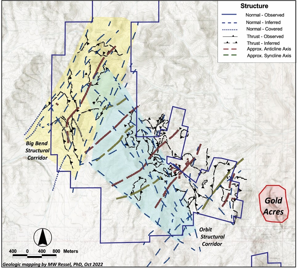
Figure 8: Structural corridors
The geology of the PWC area (figure 9) is comprised of ‘Upper Plate’, from oldest to youngest; mixed lithologies of the Ordovician Valmy, the Silurian Elder Sandstone, and the Devonian Slaven Chert. Three upper-plate thrust sheets involve the Slaven, Elder, and Valmy. Stacking order is generally backwards, older-over-younger. Diorite and gabbro intrusions of uncertain age. Skarn of possible lower-plate Wenban limestone outcrops in the southeast property corner.
Generally, structurally lowest thrust sheets flank a more elevated, NNW-trending core of higher-level Valmy Quartzite.
Hornfels alteration of the Elder Fm is pervasive in the property’s eastern sector.

Figure 9: Geology (mapped by MW Ressel, October 2022)
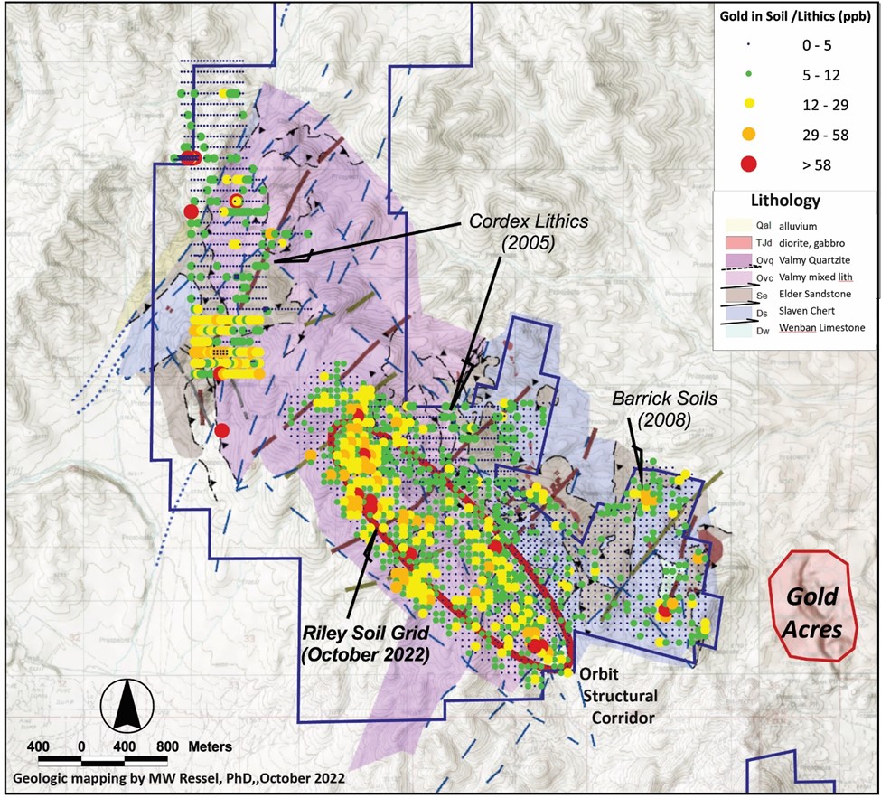
Figure 10: Gold-in-soil on geology
In Figure 10, the gold-in-soil values are overlain on geology. One set of anomalous values coincide with the northwesterly trending Orbit structural zone. It appears to have been a significant fluid migration pathway and may play host to structurally controlled Carlin-type gold mineralization.
Another, even stronger gold-in-soils anomaly appears at structural intersections and along a lithologically controlled zone within Ordovician Valmy quartzite. The quartzite, being brittle and subject to greater fracturing, may also provide fluid migration pathways for metals rising above deeper target zones in Antler lower-plate carbonate rocks that are the primary host strata for Carlin-type deposits in northern Nevada. Results for arsenic, antimony, and mercury show similar patterns. Maps for those pathfinder elements are posted below this review.
Alteration is widespread in the Upper Plate rocks. Various alteration types are mapped in Figure 11. Notice, especially, the large zone of hornfels and localized skarn in the east and southeast portions of the mapped area. Hornfels and skarn at PWC are related to the intrusion of the proximal Gold Acres Stock.

Figure 11: Alteration on Structure
Hornfels is a fine-grained metamorphic rock that was subjected to the heat of contact metamorphism at a shallow depth. It was “baked” by heat conducted from a nearby magma chamber, sill, dike, or lava flow. Because directed pressure does not play a significant role in the formation of hornfels, it is often made up of mineral grains that are equidimensional in shape and without a preferred orientation. The grain shape and orientation might also be inherited from its parent rock.
Skarn is a metamorphic rock that has been chemically and mineralogically altered by metasomatism. Metasomatism is the alteration of rocks by hot, chemically-active fluids that flow or diffuse through the rocks and cause recrystallization and compositional change. Skarn commonly forms around the edges of a magma body that intrudes a nearby rock mass.
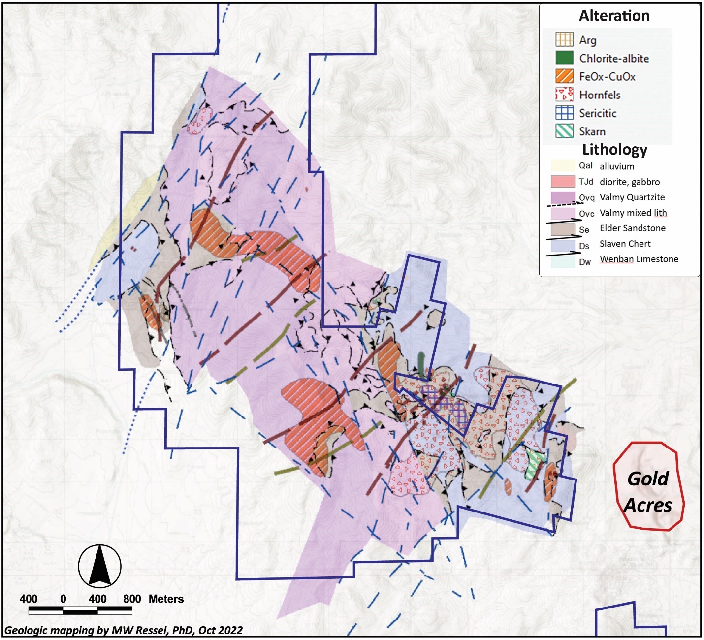
Figure 12: Alteration on geology (Note the hornfelsed area*)
These metamorphic rocks and alteration areas are important to the overall understanding of the type of gold mineralizing system occurring at PWC. Both Carlin-type and Intrusion Related models may be present.
A geochemical signature for an RIRG system appears to focus on the area east and north of the Orbit structural corridor.
Alteration mapped at PWC conforms with structure for the most part. A relatively large area of the Orbit and eastern portion of the main claim block northeast of the Orbit structural corridor display hornfels alteration. Hornfelsing of Upper Plate rocks indicates proximity to intrusive- related alteration. This suggests that RIRG mineralization may occur in the lower portions of upper plate units and in Lower Plate carbonate rock, similar to that being developed at Tenabo.
Pathfinder elements often associated with RIRG gold-silver systems include bismuth, arsenic, lead, copper, and antimony. Bismuth-in-soil is especially indicative of potential intrusive-related alteration and potential gold targets. Figure 13 show Bismuth-in-sol results for all three sets of soil/lithic sample data. There is a remarkable correlation between bismuth and the northeastern margin of the Orbit structural zone and areas of hornfels alteration.

Figure 13: Bismuth-in-soil on Geology
This strong correlation is further supported by CSAMT and previously shown gravity and magnetic maps (above). The correlation with CSAMT might best be shown by Figure 14, Bismuth-in-soil plotted on Conductivity at 1,750 m elevation.

Figure 14: Bismuth soils on CSAMT slice at 1700 m elevation.
For Reference – Carlin-Type Deposits:
Carlin-type gold deposits are generally epithermal replacement gold deposits where sub-micron sized gold particles occur in or around minute pyrite and arsenopyrite clusters in altered, silty to sandy calcareous or carbonate rocks. Mineralizing fluids migrate up or along through-going structures and react with the sediments. These carbonate rocks can also be very carbonaceous (rich in organic carbon). The fluids tend to be acidic and attack the calcite in the carbonate (reactive) rocks. By dissolving the calcite from the silty or ‘dirty’ carbonates, enough of a framework remains to prevent collapse of the sediment allowing gold and sulfides to deposit. The sulfides are deposited due to the reducing nature of the organic carbon in the sediments. As the fluids spread through the rock, the temperature and pressure of the fluids drops. The change in acidity in the fluids along with coincident drops in temperature and/or pressure cause the gold to drop out of solution along with the sulfides. This process is called sulfidation.
Sometimes, the upper portions of these deposits are oxidized, destroying the sulfide minerals, and the gold can be recovered using heap leach technology. However, most ores are reduced, with up to several percent sulfides and must be milled, and oxidized via autoclave or roaster in order to free the gold for recovery. Carlin-type systems can form huge, multi-million-ounce gold deposits.
Interest in the Cortez area started in 1966 when the USGS reported anomalous gold in altered outcrops at the base of the Cortez Range. Mining has been ongoing since 1969 at Cortez. Several operators have worked on PWC over the years, but their approach was always the same. They focused on exploratory groundwork and drilling, usually offsetting older drill holes that intersected gold mineralization in the Lower Plate of the Roberts Mountains Thrust Fault. Some results were encouraging, but little attention was paid to looking at the property and underlying system as a whole.
With the benefit of time and building on the good work of others, Riley Gold was able to assemble and re-model older information from drilling to geochemistry and geophysics for a fresh look and a new approach to the exploration of PWC.
Early Exploration:
Historical exploration included reverse circulation and core drilling, and while many drill holes were targeted at shallow silver occurrences near the historic Utah and Clipper silver mines within the PWC land package, much of the drilling was aimed at Carlin-style gold mineralization in the lower plate of the RMT system, primarily in the southeastern portion of the project area. Drilling was first conducted in 1992, but Since 1994, drilling by other operators [such as Agnico-Eagle, Barrick Gold (Placer Dome), Columbus Gold, Hemlo Gold (Noranda Exploration), Navaho Gold, and Uranerz] generally focused on offsetting early drilling that intersected gold mineralization in the Lower Plate of the Roberts Mountain Thrust.
While some of the targets for these early holes were based on anomalous gold and pathfinder elements in soil sampling, mapping and limited geophysical work (ground magnetic) surveys. Most of the geophysical work, including the gravity and a CSAMT survey over the southern portion of PWC went largely un-utilized.
Drilling:
Historical drilling returned results of 4.6 m of 2.594 gpt at 324 m including a high value of 3.84 gpt gold at 283 m in rocks of the lower plate of the Roberts Mountain Thrust (“RMT”). Drill logs also show that the Devonian Wenban (“Wenban”) was intersected in most of the holes that penetrated to the lower plate. The Wenban is the primary host to gold mineralization in the prolific Cortez District, although the Silurian-Devonian Roberts Mountain Formation is also known to be an economic host rock in the Cortez Trend.
Future drilling will test 300-600 m deep, high-grade Carlin-type and Potential RIRG gold targets along a 3-km trend defined by the red ellipse (see Figure 3). These drill targets are supported by gold-in-soil and other pathfinder element anomalies, recent mapping, and a re-interpretation of historical geophysical data.
The above information has been reviewed and approved by Richard DeLong, P.Geo., Director of Riley Gold and a ‘qualified person’, as defined by National Instrument 43-101, Standards of Disclosure for Mineral Projects. Older drilling results, from 1992 on, are quoted for historical reference only.