Battle Mountain – Eureka Trend

On the Edge of Discovery

The Pipeline West/Clipper Gold Project

Pipeline West/Clipper Gold Project

Operated by Kinross Gold through Earn-In Agreement
Figure 1a: Location of PWC
Figure 1b: Location of PWC
PWC Overview

The Pipeline West-Clipper Gold Project (“PWC”) is subject to an earn-in, and is operated, by Kinross Gold. PWC is located in Lander County, approximately 80 km southwest of Elko. PWC lies within and is directly on strike with the Cortez portion of the prolific Battle Mountain – Eureka Trend of world-class gold and base metal mines.  PWC encompasses 27.2 square kms (10.5 square miles) of unpatented mining claims and patented (fee) lands adjacent to properties controlled by the Nevada Gold Mines JV .

Kinross Earn-in Agreement Highlights:

  • First Earn-In Right: Kinross will assume operatorship of the project and can earn an initial 60% interest in PWC (the “Initial Earn-In Option”) by incurring a minimum of US$10 million in qualifying work expenditures, subject to upward adjustment in accordance with the Agreement, within five years as follows:
    • US$1.5 million in guaranteed work expenditures on or before 18 months following execution (March 13, 2024) of the Agreement (completed)(the “Effective Date”) which shall include a minimum of 2,200 meters (completed) of core drilling within three geographically distinct targets.
    • An additional US$2.5 million in work expenditures on or before 3rd anniversary of the Effective Date. (completed)
    • An additional US$2.0 million in work expenditures on or before 4th anniversary of the Effective Date.
    • An additional US$4.0 million in work expenditures on or before 5th anniversary of the Effective Date.
  • Second Earn-In Right: Kinross shall have the right to earn an additional 15% interest in PWC (for a total 75% interest) (the “Second Earn-In Option”) by incurring a minimum US$10 million in qualifying work expenditures within an additional two-year period following exercise of the Initial Earn-In Option.
  • Project Technical Committee: A Project Technical Committee to be formed including members of both Riley Gold and Kinross. (Mr. Paul Dobak was appointed Riley’s member)
  • Joint Venture: Upon exercise of the Initial Earn-in Option, a Nevada limited liability company (the “LLC”) will be formed through which Kinross and Riley Gold will hold their respective interests in PWC. Upon exercise or termination of the Second Earn-in Option, Kinross and Riley Gold will fund the on-going operations of the LLC in accordance with their proportionate interests, subject to standard dilution.
  • Dilution Provision: Should Riley Gold’s interest in the LLC be diluted to 10% or less, the Company’s interest will be converted to a 2% net smelter return royalty.
Figure 1c: Location of PWC

PWC is within 1 km of the Gold Acres Mine and is positioned between the Cortez Complex of mines operated by the Nevada Gold Mines JV (Barrick/Newmont) and the Swift Project JV between Ridgeline Minerals and Nevada Gold Mines.  PWC is centered along the Cortez Structural Zone that appears to control many of the gold deposits within the Cortez portion of the trend (Leonardson, 2010).

PWC has the potential to host significant gold deposits of two genetic types. These target models, along with hybrid situations with genetic commonalities of the two systems, have evolved from Riley Golds’s detailed review of historical drilling, geophysics, and geochemistry, combined with new programs including surface mapping and a additional, large soil geochemical sampling program.

The targets at PWC include both structurally-controlled, Carlin-type gold deposits, sometimes referred to as Sedimentary Rock Hosted Gold Deposits (SRHGD) and Reduced Intrusive Related Gold deposits (RIRG).  Both target types are in evidence at PWC based upon interpretations of the multi-layered data. 

Multiple layers of data have combined to yield significant targets for further exploration, including drilling.

PWC 2026 Exploration Program

Kinross has confirmed planning is underway for a committed next phase of exploration at PWC which will include additional framework drilling in 2026, based on the 2025 and 2024 drill results. A second soil geochemical survey is currently underway expanding the previous soil survey coverage to the southwest to fully delineate the existing +3km open gold and pathfinder element soil anomaly. Kinross has also increased the PWC property size by 2.5 square kilometers with additional claim staking. A comprehensive Leapfrog 3D geologic model for targeting is being updated for comparison with the many Cortez Districts >5.0-million-ounce gold discoveries. The primary target being a large, Carlin-type gold deposit peripheral to the Gold Acres stock, which is the geologic setting for Nevada Gold Mines LLC’s (“NGM”) Pipeline gold deposit. The PWC geological model is testing an analogy to NGM’s Meikle Mine and Barrick Mining Corporation’s (“Barrick”) Fourmile Project.

Drilling Location Overview

Kinross drilling to date consisted of three framework drill holes PW24-01, PW25-02 and PW25-03 (Figure 2 and 3 below), with this year’s drilling stepping out more than 2.5 kilometers northwest of the first drill hole (PWC24-01). PW25-02 and PW25-03 targeted a +3km long north-south trending gold and pathfinder element soil anomaly at a structural intersection of major northwest and north trending faults (Figure 3 from Riley Gold’s soil survey included news release dated February 8, 2023).

Figure 2. Picture looking from NGM’s Pipeline Deposit westward proximal to PWC drilling (Bradley, et., al., 2020)
Figure 3. PWC Gold Project drill hole locations, previous gold-in-soil survey, targeted structures and increased project size to the southwest

2025 PWC Drilling by Kinross

Drill results and logging confirm Carlin-type fluid signatures are present in PW25-02 and PW25-03, representing a possible Carlin-type gold system within the PWC claim block. These fluids are not only present in the lower plate (Horse Canyon and Wenban formations) but also as leakage anomalies along brittle high-angle structures in the upper plate above the Roberts Mountains Thrust (“RMT”) that could be the source of the gold-in-soils at surface (Figure 6). Tracking these faults down to a higher grade trapped source is one target concept. Mineralized faults in the upper plate rocks are significant with notable discoveries such as the Meikle and Fourmile deposits showing leakage of Carlin-type hydrothermal fluids from the lower plate to the upper plate (See Figure 4 below). Additional framework drilling in 2026 is planned to develop vectors towards possible high-grade mineralized zones.

2025 Kinross Drilling Highlights 

Assays from ALS Labs (Reno, NV) confirm numerous zones of gold representing leakage along high-angle structures above the RMT. Highlights within the upper and lower plate zone include:

Drill hole PW25-03

  • 26.80 feet (“ft”) (8.17 meters (“m”)) of 0.53 grams per tonne (“g/t”) gold from 2,074.5ft (632.31m) including 13.32ft (4.06m) of 0.74 g/t gold from 2,088ft (636.42m) upper plate
  • 14ft (4.26m) of 1.33 g/t gold at 2,639ft (804.37m), including 4ft (1.22m) of 2.19 g/t gold from 2,639ft (804.37m), fault gouge with a carbon seam in a high-angle structure just above the RMT contact (see core box photo below Figure 5).
  • 16.3ft (4.97m) of 0.33 g/t gold from 2,937ft (895.2m) at the transition from upper to lower plate in a high-angle brittle structure with arsenian pyrite. (see core box photo below Figure 6).
  • 489ft (149.05m) of 0.09 g/t gold from 3,415ft (1040.9m), including 15ft (4.57m) of 0.66 g/t gold from 3,585ft (1092.7m) and 5ft (1.52m) of 0.82 g/t gold from 3,585 ft (1092.7m). (see core box photo Figure 5). This thick interval of lower grade gold mineralization contains strong Carlin-type geochemical pathfinder elements including arsenic, antimony, mercury and thallium indicating disseminated Carlin-type mineralization(see core box photo below Figure 7)

(Core drill intercepts are apparent thickness and the true thickness is not known at this time. Further drilling and analysis will be required to determine true thickness.)

Figure 4. Schematic diagram of a Carlin type deposits pictured above showing ore deposit settings with ore zones and fluid pathways. Examples of such deposits are Meikle and Fourmile. (Modified from: Carlin Type Gold System Exploration - 911Metallurgist)
Figure 5. Core box photos of PW25-03 2,639ft (804.37m) to 2,653ft (808.63m) fault gouge in high angle upper plate structure with carbon seam and gold plus As, Sb, Hg and Tl.
Figure 6. Core box photos of PW25-03 lower plate from 2,937ft (895.20m) to 2,953.3ft (900.17m) showing hydrothermal breccia vein with white dolomite matrix-cement with mosaic to rotated clast breccia. This structure shows a multi-stage event, variably pyritized, with fault gouge matrix in the Wenban limestone.
Figure 7. Core box photos of PW25-03 lower plate from 3,585ft (1092.7m) to 3600ft (1097.28m) showing black carbonaceous laminated Wenban limestone with disseminated Carlin-type gold mineralization.

Drill hole PW25-02

  • 19.52ft (5.95m) of 0.43 g/t gold from 2,740ft (835.15m), including 4.5ft (1.38m) of 0.79 g/t gold from 2,755ft (839.72m) in a high-angle brittle fault at the RMT contact.
  • 10.5ft (3.2m) of 0.51 g/t gold from 3,157.5ft (964.1m) in a high-angle brittle fault cutting calc-silicate skarn below the RMT.
  • 2ft (0.61m) of 0.59 g/t gold from 3,187ft (971.4m) high-angle brittle fault cutting calc-silicate skarn below the RMT.

 (Core drill intercepts are apparent thickness and the true thickness is not known at this time. Further drilling and analysis will be required to determine true thickness.)

Downhole Geochemistry Significance

PW25-02 and PW25-03 drill holes are 250m apart and were targeting concepts around gold-in-soil anomalies. The two holes have similar geochemical properties, are both cut by high-angle structures with anomalous gold and pathfinder elements and show evidence of significant folding.  PW25-03 contains significantly higher gold values, and structural zones with much elevated pathfinder element values.  The downhole lithology and geochemistry, shown in Figure 6 below, indicates the approximate location of the RMT at 2,950ft (899.2m).  The data also shows spikes in gold and trace element values at high-angle structures in the upper plate section and elevated gold and trace element values indicating disseminated mineralization in a 149.05m (489ft) thick section of carbonaceous limestone of the Wenban Formation at the bottom portion of the drill hole.

Figure 8. Fence diagram of gold plus pathfinder geochemistry for PW25-2 and PW25-3

Historical Exploration Work

Surface Soil Geochem Sampling Program:

Historical surface soil and lithic chip sampling programs presented an intriguing question.  Open-ended gold-in-soil anomalies from past programs suggested a northwest trending anomalous zone. This zone coincided with historical and geophysical interpretations and new geological and structural mapping.  Based on the multi-layered data, we designed a detailed infill soil program.

Figure 9: Historic sample grids showing gold-in-soil plus Riley Golds’s new sample grid

A large (1,046 sample) close-spaced soil grid survey was performed in October, 2022. North American Exploration, Salt Lake City, UT conducted the sampling. Sample spacing was 60.9 m (200 feet). The samples were logged, as were the soil profiles and lithic fragments in each sample. The purpose of the soil program was to infill areas not previously sampled by former operators and to verify/level the results from prior soil and lithic chip sampling surveys.

Figure 10: Combined Gold-in-soil results (new gold-in-soil at same ranking as older surveys)

The results of the survey revealed that gold is strongly anomalous compared to older surveys.   Arsenic silver, and other pathfinder metal anomalies are also anomalous.  The new sampling confirmed older sampling results revealed new, even stronger values in areas not previously sampled.  Figure 10 shows the new gold-in-soil results overlain on older survey results.  The original target area is outlined in red.

Geophysics:

Historical geophysical work at PWC includes Ground and Aero-Magnetic surveys, Gravity, and CSAMT.   Modeling and interpretations were provided by Chet Lide, VP & Managing Geophysicist for by Zonge International, Reno, Nevada.   Modeling of the various geophysical surveys in 2022 revealed significant structure-related and alteration anomalies. These interpretations were brought sharply into focus when combined with recent geologic mapping conducted by Mike W. Ressel, PhD, during October 2022.  Initial structural interpretations, prior to field mapping, suggested northwest and northeast structural trends.  The following four figures illustrate the agreement between inferred structures and mapping.

Figure 11: Horizontal Gradient of CBA Gravity showing interpreted structures.

A gravity survey covering most of the main PWC claim block was conducted in 1994. The data support a shallower depth to carbonates of the Lower Plate of the Roberts Mountains Thrust, in the southeast portion of PWC.  The data was re-modeled in 2021-2022 (Lide, 2022) and presented several interesting structural interpretations, too.  Perhaps the best image to illustrate these structural ideas comes from the Horizontal gradient of the Complete Bouguer Anomaly (CBA) gravity (figure 11, above).  The Horizontal Gradient of the Complete Bouguer Anomaly (CBA) Gravity produces a peak/anomaly (warm colors) over high-angle density contrasts (faults or contacts) helping to reveal structures, essential to mineralizing fluid flow.  Note the structures inferred from this interpretation.

Figure 12: Horizonal Gradient of the RTP Magnetics with interpreted structures and inferred target ellipse.

Similarly, the horizontal gradient of RTP magnetics reveals changes in the magnetic susceptibility of rock (warm colors). This information may help constrain structures and alteration. High gradients signal changes in the magnetic mineral content of rock, either indicating a marked increase or decrease in minerals such as magnetite (often in igneous rock) or pyrrhotite as part of a hydrothermal alteration zone.  Note that such a gradient is highlighted within the red ellipse.  Gold Acres Pit is also aligned on the edge of a steep gradient.  NOTE: The gradient at Gold Acres appears greater due to the alteration associated with that gradient is closer to the surface than at PWC.

Geology and Alteration:

During October 2022, Mike Ressel conducted geologic mapping on a sizeable block of PWC.  First, looking at the structure map of the area, there is good agreement between mapped structures and those inferred by interpretation of various geophysical surveys.

Figure 13: Mapped Structures (M. Ressel, fall2022) on Horizontal Gradient of CBA Gravity
Figure 14: Horizonal Gradient of the RTP Magnetics showing mapped structural agreement.

Mapping at PWC revealed two general structural trends.  As shown on Figure 13, a northwesterly striking structural zone (Orbit structural corridor) agrees well with both the horizontal gradient of the RTP Magnetics and the horizontal gradient of the gravity.  Supporting evidence such as this, strengthens the overall interpretation and drill targeting.

Along the northwestern side of the mapped area, a northeast trending structural zone (the Big Bend structural corridor) is noted towards the Clipper and Utah silver mine areas.  This area also is supported by older geophysics, especially the above horizontal gradient of the RTP magnetics.

Figure 15: Structural corridors

The geology of the PWC area (figure 16) is comprised of ‘Upper Plate’, from oldest to youngest; mixed lithologies of the Ordovician Valmy, the Silurian Elder Sandstone, and the Devonian Slaven Chert.  Three upper-plate thrust sheets involve the Slaven, Elder, and Valmy.  Stacking order is generally backwards, older-over-younger.  Diorite and gabbro intrusions of uncertain age.  Skarn of possible lower-plate Wenban limestone outcrops in the southeast property corner. 

Generally, structurally lowest thrust sheets flank a more elevated, NNW-trending core of higher-level Valmy Quartzite. 

Hornfels alteration of the Elder Fm is pervasive in the property’s eastern sector.

Figure 16: Geology (mapped by MW Ressel, October 2022)
Figure 17: Gold-in-soil on geology

In Figure 17, the gold-in-soil values are overlain on geology.  One set of anomalous values coincide with the northwesterly trending Orbit structural zone.  It appears to have been a significant fluid migration pathway and may play host to structurally controlled Carlin-type gold mineralization.

Another, even stronger gold-in-soils anomaly appears at structural intersections and along a lithologically controlled zone within Ordovician Valmy quartzite.  The quartzite, being brittle and subject to greater fracturing, may also provide fluid migration pathways for metals rising above deeper target zones in Antler lower-plate carbonate rocks that are the primary host strata for Carlin-type deposits in northern Nevada.  Results for arsenic, antimony, and mercury show similar patterns.  Maps for those pathfinder elements are posted below this review.

Alteration is widespread in the Upper Plate rocks.  Various alteration types are mapped in Figure 18. Notice, especially, the large zone of hornfels and localized skarn in the east and southeast portions of the mapped area.  Hornfels and skarn at PWC are related to the intrusion of the proximal Gold Acres Stock. 

Figure 18: Alteration on Structure

Hornfels is a fine-grained metamorphic rock that was subjected to the heat of contact metamorphism at a shallow depth. It was “baked” by heat conducted from a nearby magma chamber, sill, dike, or lava flow. Because directed pressure does not play a significant role in the formation of hornfels, it is often made up of mineral grains that are equidimensional in shape and without a preferred orientation. The grain shape and orientation might also be inherited from its parent rock.

Skarn is a metamorphic rock that has been chemically and mineralogically altered by metasomatism. Metasomatism is the alteration of rocks by hot, chemically-active fluids that flow or diffuse through the rocks and cause recrystallization and compositional change.  Skarn commonly forms around the edges of a magma body that intrudes a nearby rock mass.

Figure 19: Alteration on geology (Note the hornfelsed area*)

These metamorphic rocks and alteration areas are important to the overall understanding of the type of gold mineralizing system occurring at PWC.  Both Carlin-type and Intrusion Related models may be present. 

A geochemical signature for an RIRG system appears to focus on the area east and north of the Orbit structural corridor. 

Alteration mapped at PWC conforms with structure for the most part.  A relatively large area of the Orbit and eastern portion of the main claim block northeast of the Orbit structural corridor display hornfels alteration.  Hornfelsing of Upper Plate rocks indicates proximity to intrusive- related alteration. This suggests that RIRG mineralization may occur in the lower portions of upper plate units and in Lower Plate carbonate rock, similar to that being developed at Tenabo.

Pathfinder elements often associated with RIRG gold-silver systems include bismuth, arsenic, lead, copper, and antimony.  Bismuth-in-soil is especially indicative of potential intrusive-related alteration and potential gold targets.  Figure 20 show Bismuth-in-sol results for all three sets of soil/lithic sample data.  There is a remarkable correlation between bismuth and the northeastern margin of the Orbit structural zone and areas of hornfels alteration.

Figure 20: Bismuth-in-soil on Geology

This strong correlation is further supported by CSAMT and previously shown gravity and magnetic maps (above).  The correlation with CSAMT might best be shown by Figure 21, Bismuth-in-soil plotted on Conductivity at 1,750 m elevation.

Figure 21: Bismuth soils on CSAMT slice at 1700 m elevation.

For Reference – Carlin-Type Deposits:

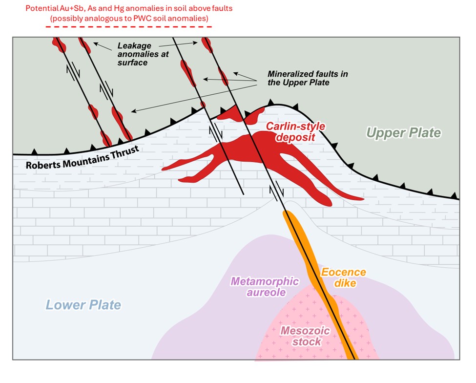
Carlin-type gold deposits are generally epithermal replacement gold deposits where sub-micron sized gold particles occur in or around minute pyrite and arsenopyrite clusters in altered, silty to sandy calcareous or carbonate rocks. Mineralizing fluids migrate up or along through-going structures and react with the sediments. These carbonate rocks can also be very carbonaceous (rich in organic carbon). The fluids tend to be acidic and attack the calcite in the carbonate (reactive) rocks. By dissolving the calcite from the silty or ‘dirty’ carbonates, enough of a framework remains to prevent collapse of the sediment allowing gold and sulfides to deposit. The sulfides are deposited due to the reducing nature of the organic carbon in the sediments. As the fluids spread through the rock, the temperature and pressure of the fluids drops. The change in acidity in the fluids along with coincident drops in temperature and/or pressure cause the gold to drop out of solution along with the sulfides. This process is called sulfidation.

Sometimes, the upper portions of these deposits are oxidized, destroying the sulfide minerals, and the gold can be recovered using heap leach technology. However, most ores are reduced, with up to several percent sulfides and must be milled, and oxidized via autoclave or roaster in order to free the gold for recovery. Carlin-type systems can form huge, multi-million-ounce gold deposits.

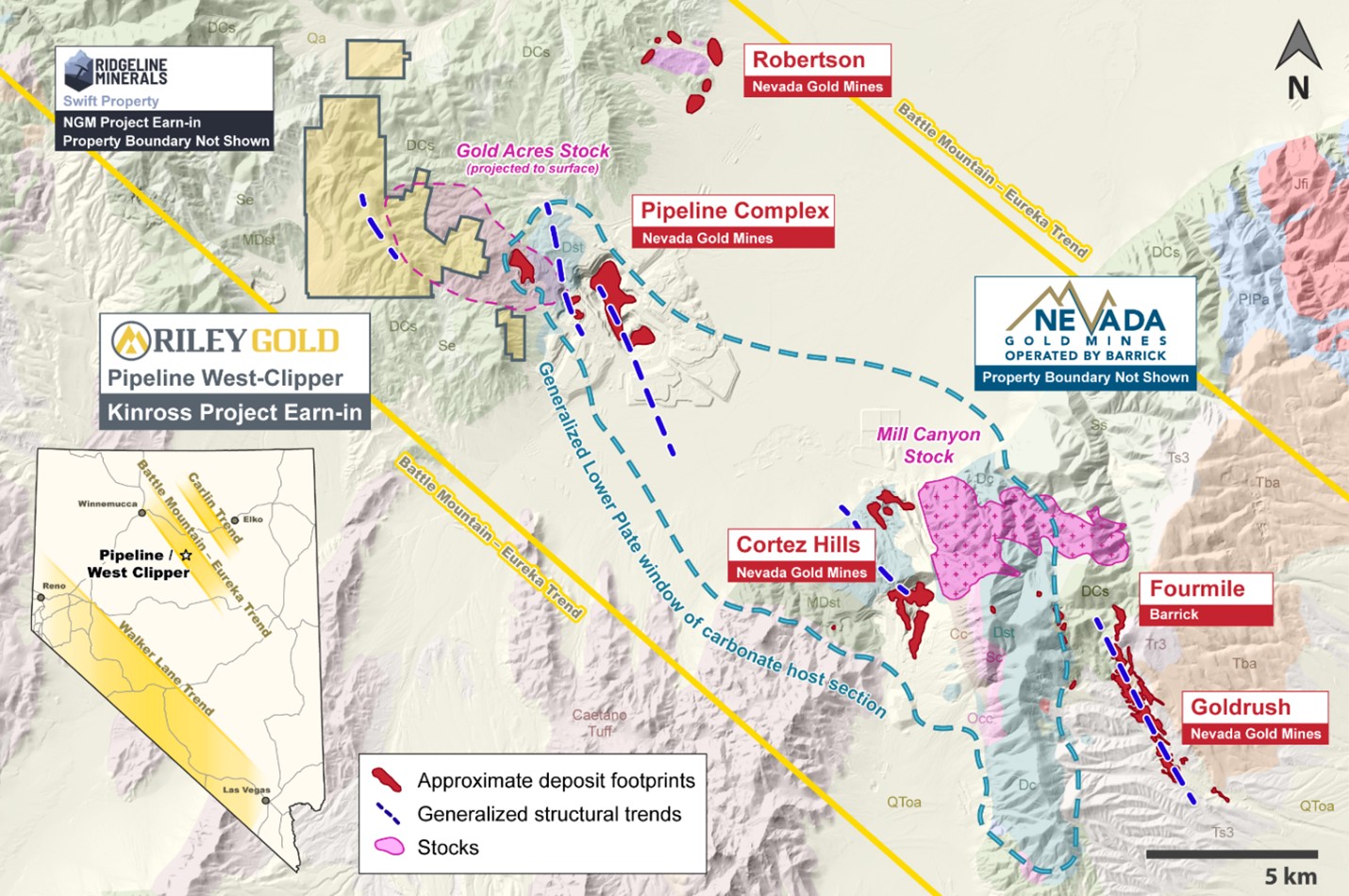
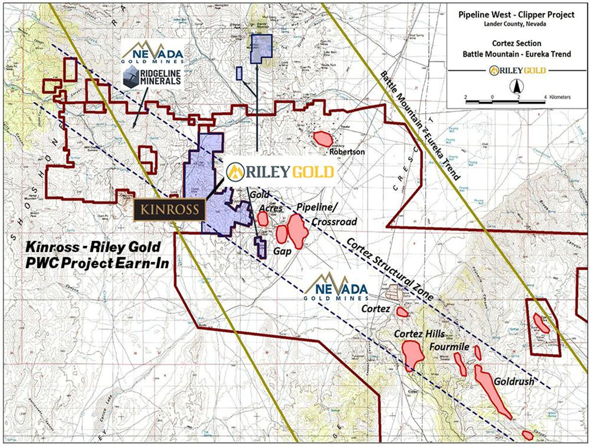
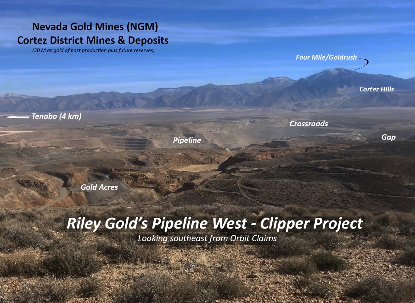
Interest in the Cortez area started in 1966 when the USGS reported anomalous gold in altered outcrops at the base of the Cortez Range. Mining has been ongoing since 1969 at Cortez. Several operators have worked on PWC over the years, but their approach was always the same. They focused on exploratory groundwork and drilling, usually offsetting older drill holes that intersected gold mineralization in the Lower Plate of the Roberts Mountains Thrust Fault. Some results were encouraging, but little attention was paid to looking at the property and underlying system as a whole.

With the benefit of time and building on the good work of others, Riley Gold was able to assemble and re-model older information from drilling to geochemistry and geophysics for a fresh look and a new approach to the exploration of PWC.
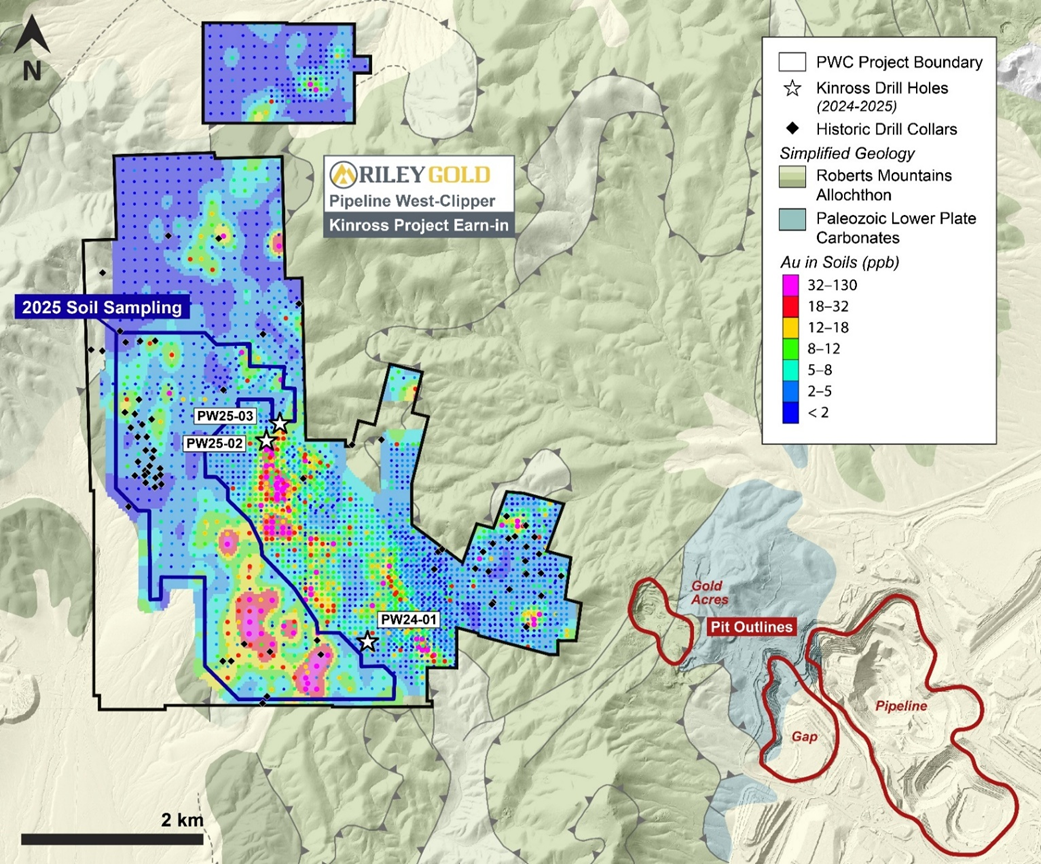
Early Exploration:

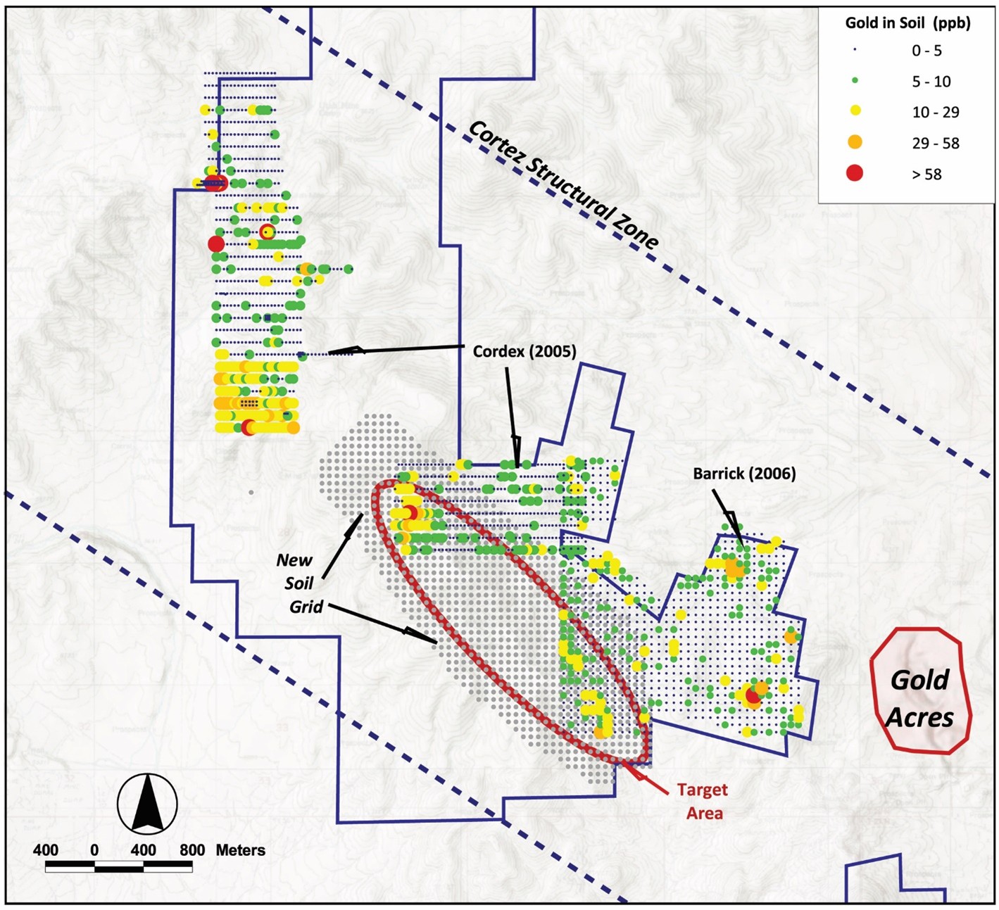
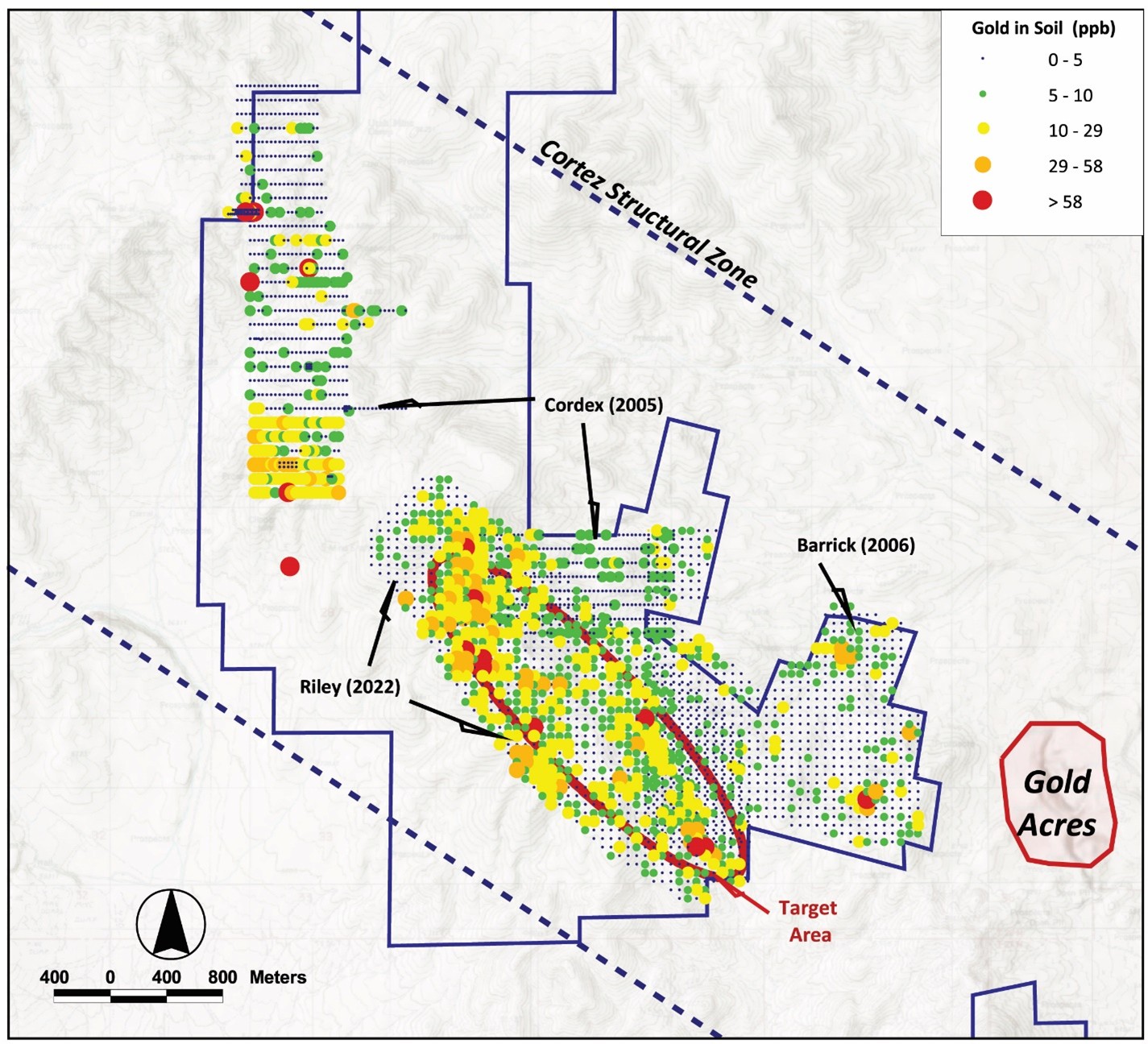
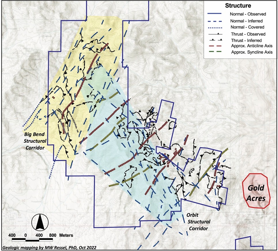
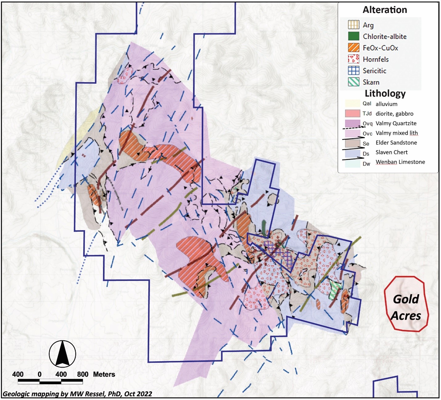
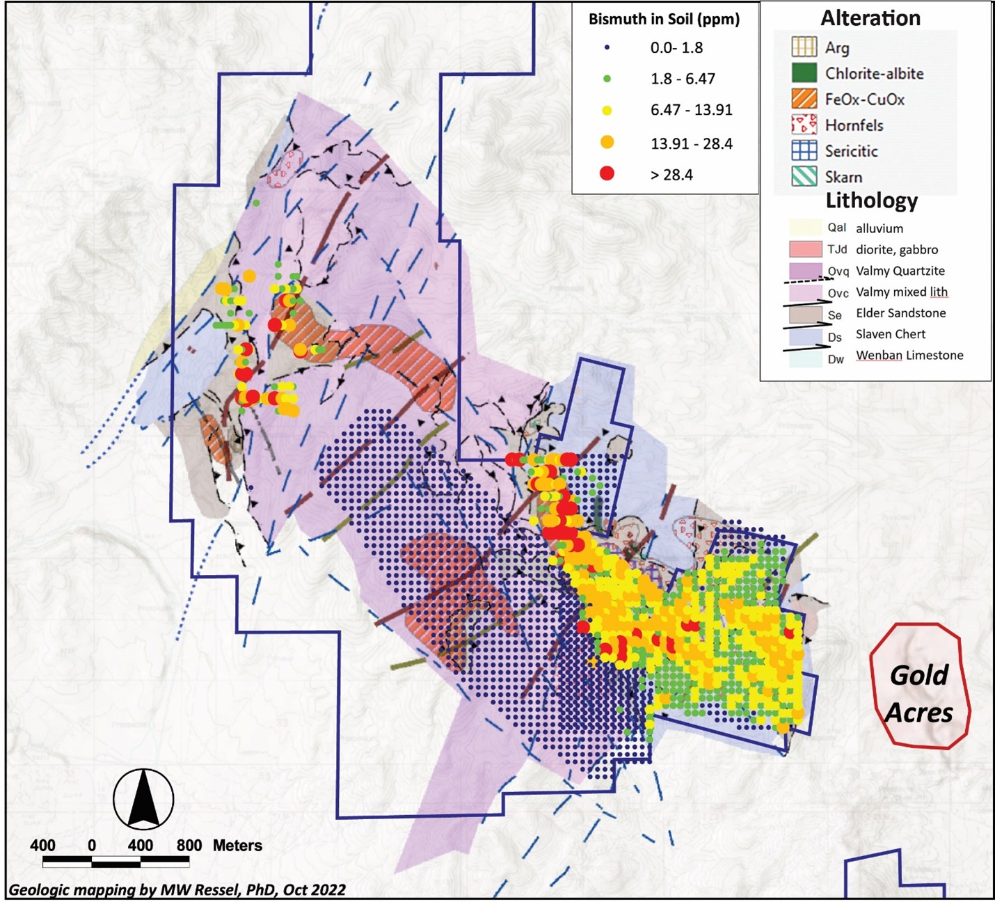
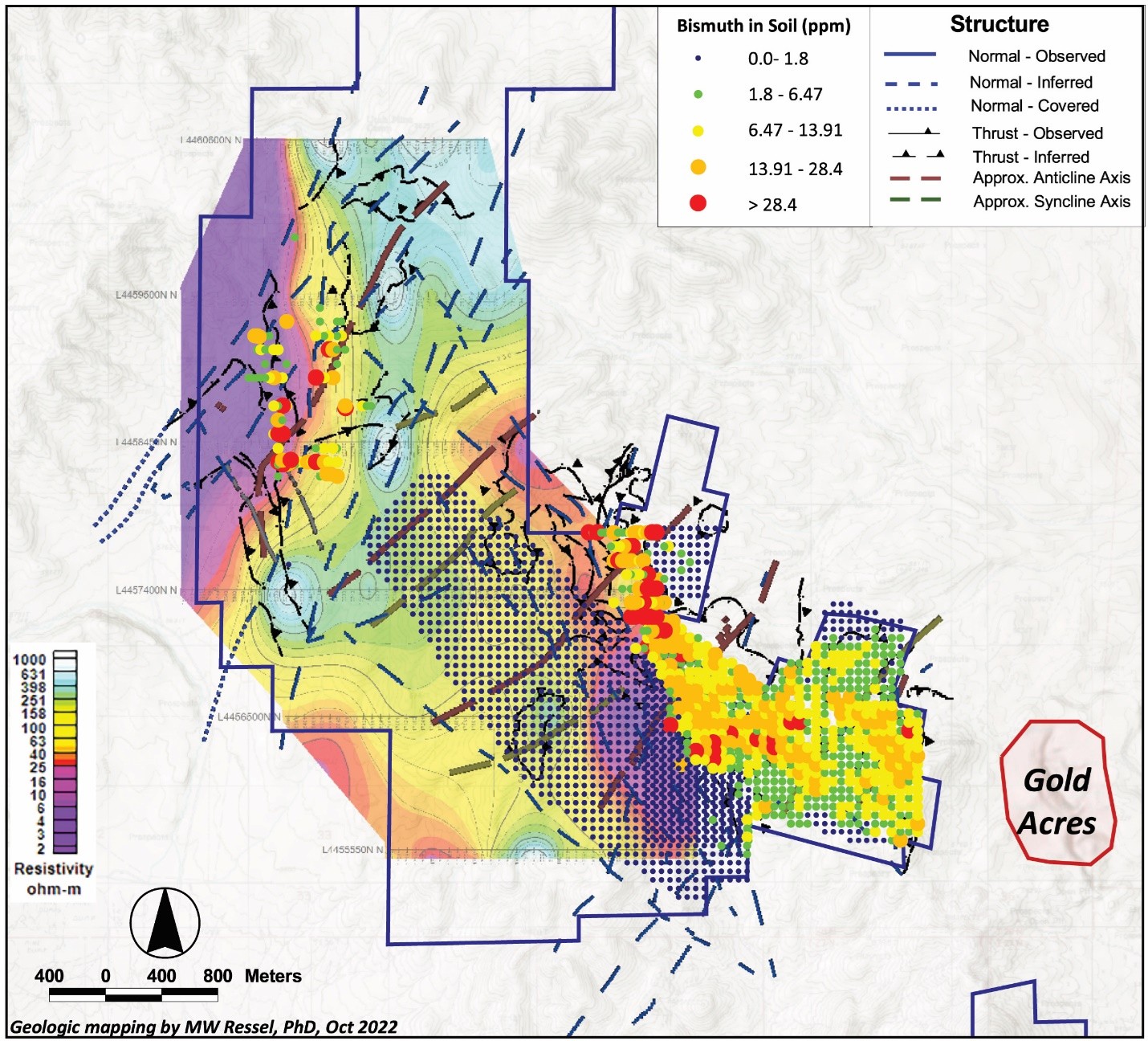
Historical exploration included reverse circulation and core drilling, and while many drill holes were targeted at shallow silver occurrences near the historic Utah and Clipper silver mines within the PWC land package, much of the drilling was aimed at Carlin-style gold mineralization in the lower plate of the RMT system, primarily in the southeastern portion of the project area.  Drilling was first conducted in 1992, but Since 1994, drilling by other operators [such as Agnico-Eagle, Barrick Gold (Placer Dome), Columbus Gold, Hemlo Gold (Noranda Exploration), Navaho Gold, and Uranerz] generally focused on offsetting early drilling that intersected gold mineralization in the Lower Plate of the Roberts Mountain Thrust.  

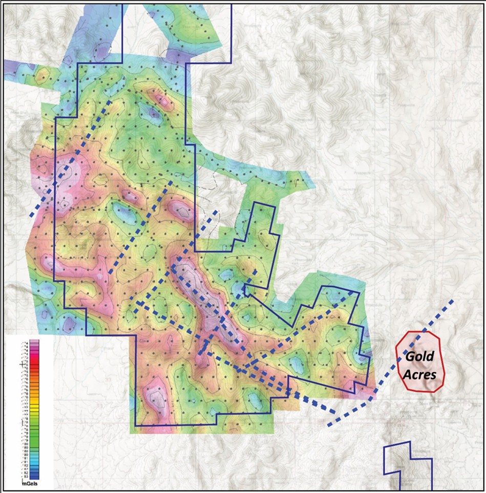
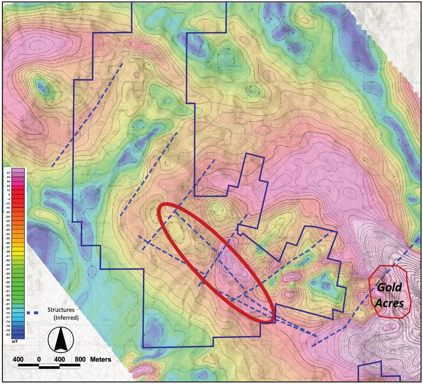
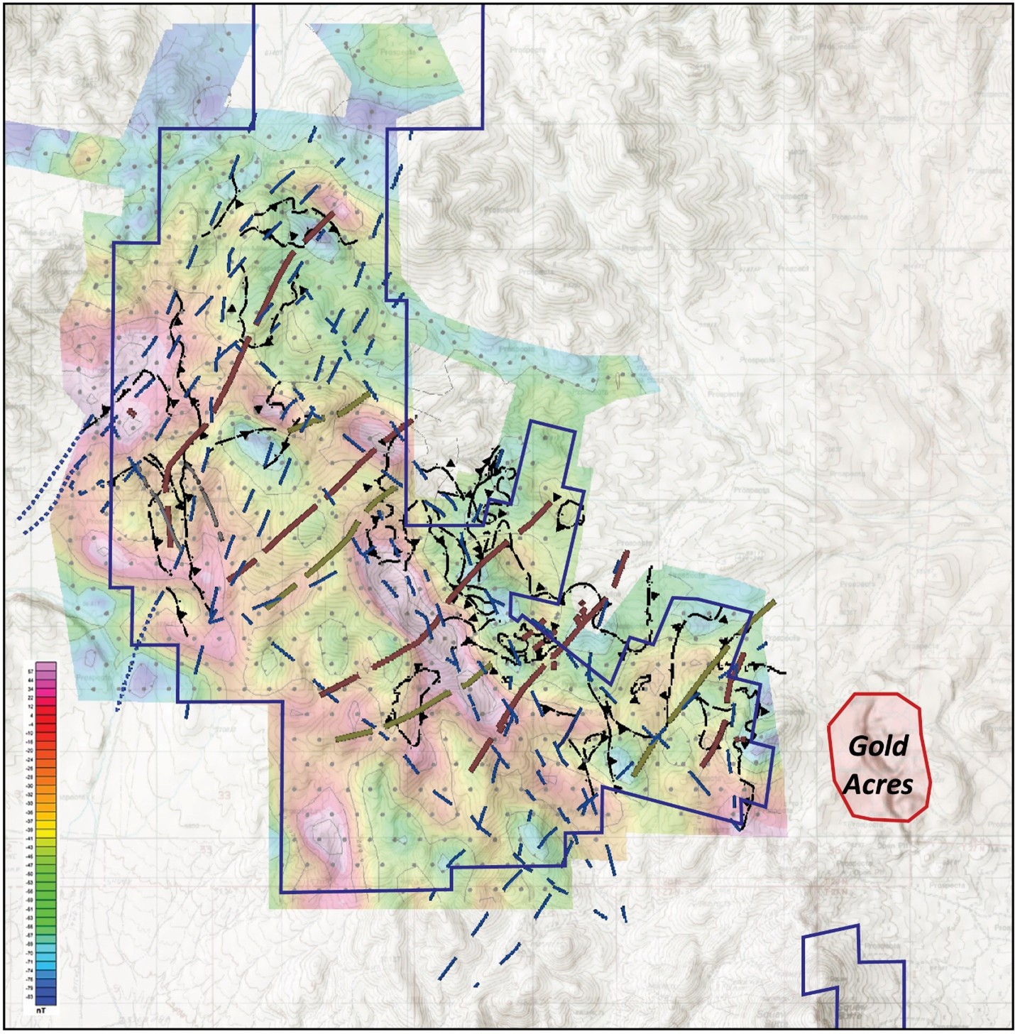
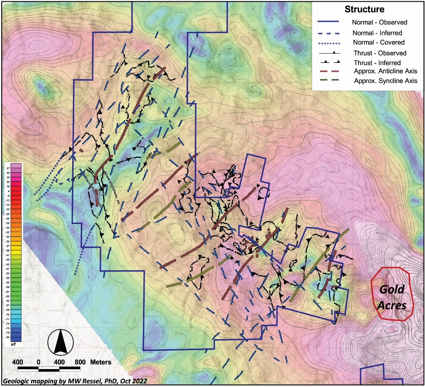
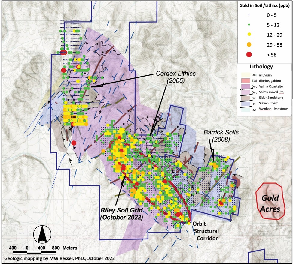
While some of the targets for these early holes were based on anomalous gold and pathfinder elements in soil sampling, mapping and limited geophysical work (ground magnetic) surveys. Most of the geophysical work, including the gravity and a CSAMT survey over the southern portion of PWC went largely un-utilized.

Drilling:

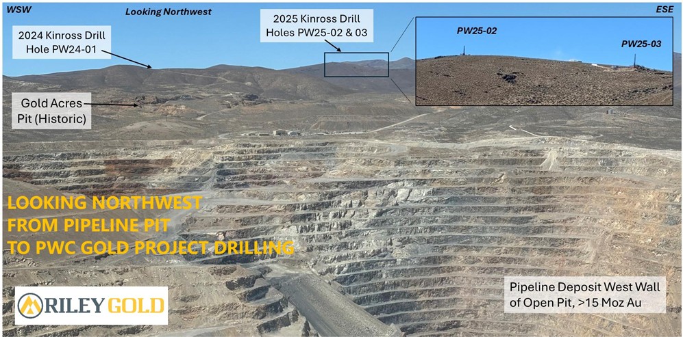
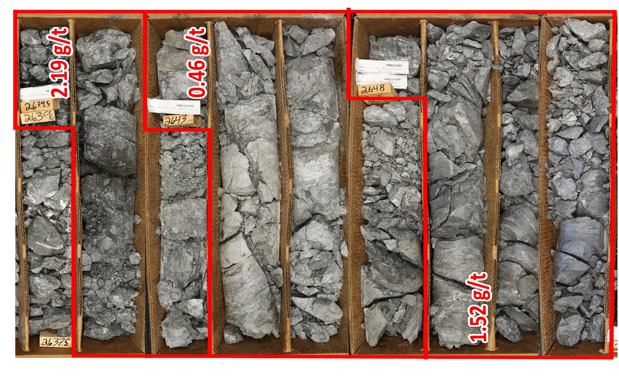
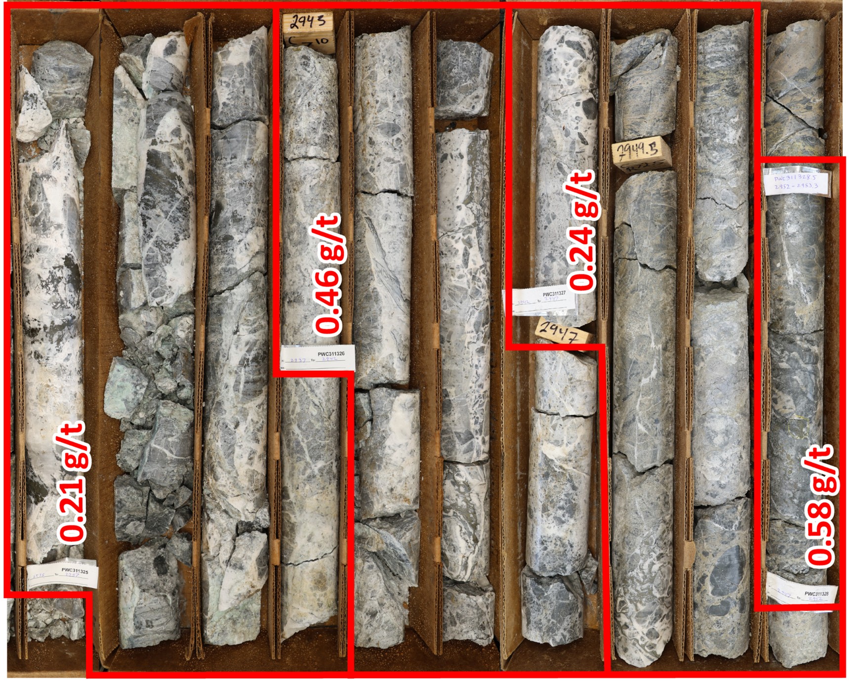
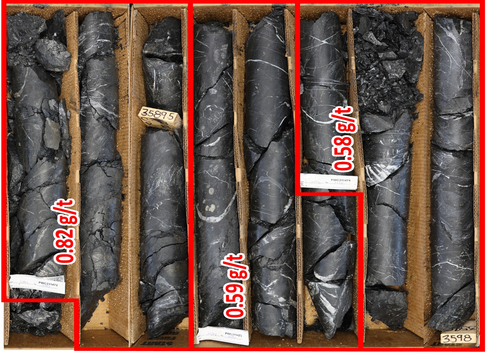
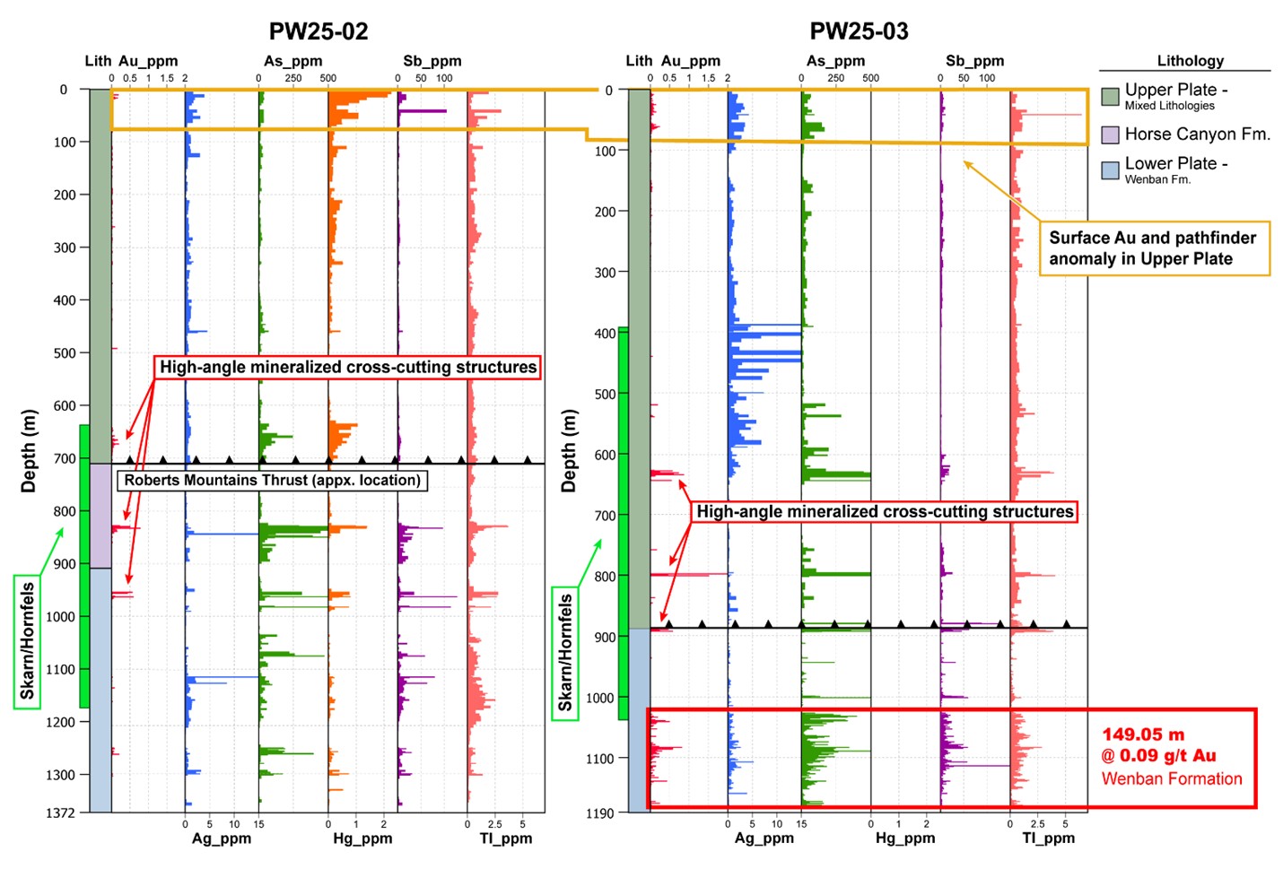
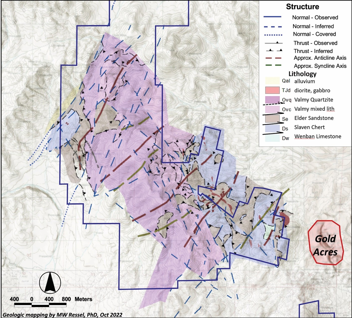
Historical drilling returned results of 4.6 m of 2.594 gpt at 324 m including a high value of 3.84 gpt gold at 283 m in rocks of the lower plate of the Roberts Mountain Thrust (“RMT”). Drill logs also show that the Devonian Wenban (“Wenban”) was intersected in most of the holes that penetrated to the lower plate. The Wenban is the primary host to gold mineralization in the prolific Cortez District, although the Silurian-Devonian Roberts Mountain Formation is also known to be an economic host rock in the Cortez Trend.

The above information has been reviewed and approved by Richard DeLong, of Riley Gold and a ‘qualified person’, as defined by National Instrument 43-101, Standards of Disclosure for Mineral Projects. Older drilling results, from 1992 on, are quoted for historical reference only.